SUBMITTED BY SALT SPRING ISLAND HISTORICAL SOCIETY AND ARCHIVES
National Indigenous Peoples Day is June 21. As newcomers living on these unceded First Nation territories, we can educate ourselves every day about the land and people whose territories we occupy.
Consider making June a jumping-in point to begin or to further your knowledge of local First Nation history, challenges, continuing strong presence and resurgence.
If you live on the north end of the island, you can say that you live near P’q’unup. If you are travelling south to “Ruckle” you are going toward ȾESNOEN or (S)ts’usna’um’.
And now, you can learn to pronounce these ancient names.
The Salt Spring Historical Society and Archives is pleased to announce an interactive First Nations Placenames Map of the island to help you do just that. The map page is a rich resource, offering names and recorded pronunciations of significant First Nation places in both the SENĆOŦEN and Hul’q’umi’num’ languages. We are grateful to ȻOSINIYE (Lindy Elliott) and Luschiim (Arvid Charlie) for lending their voices to the initiative.
This “reconcili-action” project is a direct tie-in to the Indigenous Interpretive Panels at Ganges Harbour and Fernwood Dock. The panels are beautiful and carry significant information, but only touch the surface of the layers of learning to be done/undone.
“People talk about truth and reconciliation a lot these days. Let’s talk about the truth first. Acknowledge what was actually done to our homeland and territories, and then look at reconciliation,” said J’SINTEN (John Elliott).
A team of volunteers, including Phil Vernon, Maggie Ziegler, Christina Marshall and Ceridwen Ross Collins, have been working for over five years with Elders from Tsartlip, Tsawout, Quw’utsun, Halalt and Penelakut to learn what mattered most to include on these panels. Funding for traditional artwork, interview time with Elders and the materials required for the creation of the panels was provided primarily by the Salt Spring Island Foundation and the Donna Martin Legacy Fund.
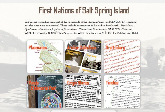
Adding QR codes allowed for the archives team, led by our formidable webmaster Brian Smallshaw, to greatly expand on content by linking the panels to the new First Nations page on our website. The landing page provides options to search collections, oral history, information about the panels, origin stories, a timeline by Chris Arnett, further links, and the Placenames Map of Salt Spring Island with clickable pronunciations by local Elders. This menu will continue to be expanded as more work is completed. Clicking on the “More” button on the map will give the viewer a comprehensive overview of the First Nation background for each labelled site, compiled by Chris Arnett.
The interactive Placenames Map project is the culmination of two decades of effort. In 2004 the late Frank Neumann of the Salt Spring Island Historical Society and Chris Arnett, anthropologist and author of books such as Terror on the Coast, began working with First Nations Elders to record placenames and any other information they were willing to share in connection to Salt Spring Island.
“It really is a privilege to be able to work on this type of project with knowledgeable Indigenous Elders to give Indigenous voice to the land,” said Arnett.
The archives team is grateful for the generous donation of Arnett’s time and for his extensive contributions to local knowledge through this project.
To view this work, a First Nations link can be found on the “Collections” page at saltspringarchives.com.
We respectfully acknowledge the following Elders for their generosity in sharing their knowledge of “Salt Spring” place names with us over the years: Earl Claxton Sr., Ray Sam, Henry Edwards, Ernie Rice, Louis Pelkey, Christopher Paul, Richard Harry, Ernie Olsen, Bob Akerman, Luschiim (Arvid Charlie), August Sylvester, Dave Elliott, J’SINTEN (John Elliott), ȻOSINIYE (Lindy Elliott) and SELILIYE (Belinda Claxton).
The above is the first of weekly articles leading up to Indigenous Peoples Weekend on Salt Spring from June 21-23.

